Drone LIDAR AErial Surveying
The Technology behind the scene:
Introduction to Drones
Drones have become key to providing accurate cost effective and efficient information of project sites. They are a standard in many industries and have the ability to provide an abundance of information in a short period of time. The Drone platform itself is the aircraft which has the ability to carry different payloads such camera sensors, lidar sensors, infrared sensors and various others. At Upland we utilize a combination Lidar/camera sensor to capture the scene to get accurate ground surface and structures.
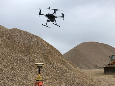
Volume & Surface Model Surveys – RTK GPS and Drones are used to calculate volumes of stockpiles and excavated areas and for mapping surfaces of sites.
Aerial Imaging – Drones are used to capture hundreds of photos of a site in a systematic grid in order to produce a quality high resolution orthoimage of the site. This product is georeferenced to a coordinate system of choice for the client.
Methodology
Upland's aircraft system is a DJI M400 Industrial quadcopter with a high resolution Lidar & camera for capturing quality Lidar data and photos of the site. The Lidar is equipped with a high grade PPK GPS system for accurate geotagging of lidar points and images.
The data captured is processed with specialized software to produce a point cloud and then generate a surface model in addition to an ortho image of the site. These generated products provide the ability to complete a variety of mapping GIS products and volumetric calculations.
Compliance
Upland Environmental Ltd is fully licensed, certified and insured to operate a Drone within Canada. Normand Menard, RPAS Pilot, holds an Advanced Pilot Certificate with Transport Canada and our Drone is registered with Transport Canada giving us the ability to operate in various airspaces. Upland carries $1,000,000 Drone liability insurance coverage. We have also acquired the necessary Drone Ground School Training for piloting the system.
Summary
A Drone with Lidar & Camera sensors is a very cost effective way to capture the most up to date aerial and topographic information of a site. This technology is becoming very popular in all types of industries around the world including municipal planning & projects, mining, aggregate development and forest industries. The key to making Drones and photogrammetry successful and effective is by utilizing sound practices, good equipment and understanding its limitations. Here at Upland we focus on providing quality accurate data to our clients.
Stockpile Volumetrics